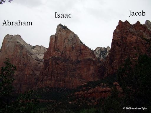
Sunday, May 31, 2009

May 30

Miles Traveled: 102
Total Miles:5265

Today we drove into Yosemite. It is a large valley surrounded with 2000-3000 ft high cliffs. We could see at least 5 waterfalls. Some of the formations/cliffs that we saw were Sentinel Dome,
El Capitan and Half Dome. The waterfalls were magnificent with all the spring water flowing over them. We took a short hike to Bridal Veil Fall, and a 3 mile hike to Vernal Fall. The trail was nicely paved, but there was a lot of people on it, and by the falls lots of water was running down the steps, making it very slick. About a mile from the end of the trail, it started to rain. By the time we got back to the shuttle, we were cold and wet. It was simply amazing to see high cliffs and waterfalls in every direction you look from the valley floor.


May 29

Miles Traveled:221
Total Miles:5163

We traveled from Sequoia National Park toward Yosemite National Park. The last 30 miles were twisty, turny, steep roads that we went about 20 miles an hour on. Fortunately, Yosemite Pines was a very nice campground, and we enjoyed the pool, and did our laundry. In the evening we attended a marshmallow roast and Yosemite talk by Mighty Moe and Super Dave, two very informative local characters.

Friday, May 29, 2009

May 28

Miles traveled 64
Total Miles Traveled 4942

We drove into the center of Sequoia National Park on a road that gained about 4000 feet elevation in about 15 miles. It was the twistiest and turnyest road we have ever driven on. Finally we saw giant sequoia trees. We took several hikes through the big trees and got to see many of them up close. They really are enormous. We also took a hike to the biggest tree in the world named General Sherman.

We also hiked to the top of Moro Rock, a huge granite outcropping.
*click to view the full panorama from the top*

Here is a view of Moro Rock from the road,


and a view of the road from Moro Rock.

On the way back down the mountain to the campground we saw a cinnamon colored black bear. It was a lot lighter colored then we had expected.

Wednesday, May 27, 2009

May 27

Miles Traveled 428
Total Miles Traveled 4878

We left the Las Vegas area and traveled all the way to Sequoia National Park in California. When we got to the park, the ranger told us that we needed to put food and all scented items in the bear box. The car and camper were not safe, however. In the previous 3 days, 3 vehicles were broken into by bears in our loop of the campground. They broke through the windshield of a truck to get an empty bag of chips, and they (bears) broke through the driver's side door of a car and ripped the backseat out of a car to get to food in the trunk. We decided to take them seriously.

May 26

May 26
Miles traveled:284
Total miles traveled:4450

We left Flagstaff Arizona and traveled to Boulder city Nevada near Las Vegas. We were planing to drive across Hoover dam with the camper but we learned that it would require a police search of the entire camper, so we changed our route to get there another way. We left the camper at Canyon Trail RV park and headed to Hoover dam with the car. The weather was dry and hot, the temperature was in the low 90s which we thought was hot, but the locals thought was a very pleasant temperature because the temperature gets to 130 plus in the summertime. We took the power plant tour and found it very interesting, there were 8 generators on the Nevada side, all fed from a 30 foot diameter pipe. The dam staff are constructing a by-pass road around the dam with an arch bridge, the arch bridge was not finished and it was cool to see it being built.

Tuesday, May 26, 2009

May 25

Miles traveled 348
Total miles traveled 4166

We left the Grand Canyon and traveled south to Flagstaff and dropped the trailer off at a campground. We then did something we haven't done in a few weeks, drove east. We visited Petrified Forest National Park. In the north end of the park was the painted dessert that looked like pink and blue sand dunes. Then we saw petroglyphs, ancient Indian picture carvings in rock. What we really enjoyed though was the petrified wood. There were many petrified logs strewn in the fields. Some were whole logs, some looked as if they had been sawed by a chainsaw ready to be split and there were also chunks lying on the ground. Since the cellulose of the wood was replaced by ash and the other surrounding minerals during the petrification process they are multi-colored rocks that show all the features of the original tree. Some include gems of amethyst, quartz, sapphire and many others.
Throughout the day we enjoyed seeing several thunderstorms around us since we could see for so far. The clouds were amazing. On the way back to Flagstaff we went through a severe thunderstorm. It was awesome and included a rainbow and much needed car wash.


Monday, May 25, 2009

May 23-24

Miles Traveled: 349
Total Miles: 3818

We left Bryce Campground and drove to the south rim of the Grand Canyon. When we entered Arizona, we gained an hour because Arizona isn't on DST. In Page, Arizona, we stopped and saw the Glen Canyon Dam. Once we set up at the campground and ate supper, we went to the rim of the Canyon. The immenseness and diversity in the canyon was impressive. We were surprised by the rain and cold we found there. Even though the weather was cloudy, the sunset was still pretty good. After pancakes the next morning, we headed out to the rim, where we held our own church service. The place was mobbed because it was Memorial Day weekend, and very few people were speaking English. We took a shuttle bus to Yaki point, where we hiked just under a mile on a steep trail into the canyon to Ooh Ahh point. It wasn't easy, but was worth it for the view and experience. The weather was quite warm until it started to rain on the way up. Then we were wet and cold. In the afternoon we took the shuttle to many of the scenic overlooks in the western area of the park. The sun came out and the views were spectacular. We stayed and watched a beautiful sunset at Mojave point.


*click to see full panorama*

May 22

Miles Traveled 174
Total Miles Traveled 3469

We drove to Zion National Park. As we entered the park, we saw Checkerboard Mesa, which is a large conical rock formation that has crisscrossing lines, hence the name. To get to the visitor center, we had to drive through a 1 mile long man made tunnel, and lots of switchbacks. We had to park at the visitor center and take a bus throughout the park. Zion Canyon is narrow with huge rock formations. In many places the canyon walls are gigantic shear cliffs, some of the highest in the world. Most of the formations were named by early Mormon settlers as you can tell from the names: The Patriarchs (Abraham, Isaac, and Jacob of course),
*Remember to click on the pictures to see the full image*

The Great White Throne,

Angels Landing, and The Alter of Sacrifice. We saw cacti in bloom right next to the stream. We were told that they only bloom for 2 weeks in the spring.

We took a 3 mile hike to visit the 3 Emerald Pools. The first was at the bottom of a beautiful waterfall. We climbed high to reach the 3rd pool which lay at the base of a towering shear cliff. It sprinkled several times but kept us cool. Zion is very different from Bryce, but still amazing and hard to describe.

Friday, May 22, 2009

May 21

Miles Traveled 65
Total Miles Traveled 3295
Jon and Terry got up to see the sunrise in Bryce Canyon, but it was completely cloudy. They walked part way down a trail anyway. It was about 45 degrees and windy. After breakfast all of us went down the Queen's Garden Trail and up the Navajo Loop Trail. There were many switchbacks on the steep trail but it was worth it to see the canyon up close. It seemed different at every turn. Some of the formations were named things like; Queen Victoria,

Thor's Hammer, Wall Street, the alligator, and more. The hike was quite strenuous and took a couple hours. In the afternoon we drove the rest of the rim to check out the rest of the canyon. Jon was awed at Inspiration Point with the thousands of hoodoos and how far you could see. I think it is our favorite so far. Words can't explain the beauty and we don't think our pictures grasp the grandeur either.

*Remember to click on the images below to see them in full size*


May 20

Miles Traveled 227
Total Miles Traveled 3230
We left Green River State Park with dew on the ground which we had not seen since we left the East. We did a food shopping trip and then drove to Bryce Canyon. After we set up we walked around the rim. After supper we walked down part of the Navajo trail to see the sunset. There were hundreds of beautiful hoodoos which are tall colorful columns of rock. It is VERY hard to describe what we are seeing, as you have to be here to understand.

Wednesday, May 20, 2009

May 19

May 19
Miles Traveled: 227
Total Miles Traveled: 3003

We left Mesa Verde and traveled towards Bryce Canyon. On the way we stopped and toured Arches National Park for a few hours. We saw lots of red sandstone rock formations, some in the shape of arches. The longest hike we took was to Landscape Arch, one of the longest natural arches in the world. (it is longer than a football field!)
On the hike back from the arch a thunderstorm popped up and the wind whipped up with sand and wind. When we got back to the car, a van full of Houghton College students was parked next to us. They are on a “may term” of Adventure Sports. Some of them knew Helena Tyler-Oden, and Dan Weber. We traveled on to Green River State Park in Green River, Utah and camped.

Tuesday, May 19, 2009

May 18

Miles Traveled 57
Total Miles Traveled 2776
We woke up freezing, but to a beautiful view of Mesa Verde.

We were glad not to have to travel on Dad's birthday because then we could put ribs in the Crockpot for dinner. We took a beautiful drive through the park (over 50 miles total). We saw deep canyons with steep rock walls. We saw several of the 600 ancient Indian cliff dwellings, which were very interesting. We took guided tours to 2 of them, which required climbing up and down tall ladders. One of them was especially scary, because of climbing up the rock face, like the Indians did (except for some safety fences). It was amazing that generations of Indians carried everything they needed up and down these cliff faces. The cliff dwellings had several large circular pits, called Kivas, which the Indians used for sleeping and for ceremonies. The weather was VERY hot, and we enjoyed a dip in the campground pool when we got back.
--
Rachel made it!
--
Cliff Palace

May 17

Miles Traveled 301
Total Miles Traveled 2719
We left Lathrop State Park and headed west toward Mesa Verde. On the way we stopped and went to Great Sand Dunes National Park. It was cool to climb up on big sand dunes (up to 750 feet high) right next to the mountains. The sand was toooooo hot to walk on barefoot. We drove up several mountain passes, one of which was the continental divide. The highest was Wolf Creek Pass which was 10850 feet. We made it but we didn't go very fast. We stayed at A&A Campground just out side of Mesa Verde State Park.
--
Sand Dunes next to mountains.

--
Approaching the Dunes

Monday, May 18, 2009

May 16

Miles Traveled 210 (2 days)
Total Miles Traveled 2418
Yesterday was a travel and laundry day. Today we woke to snow flurries and 35 degrees at Mueller State Park near Pikes peak and Colorado Springs at 9300 feet. We were going to go up Pikes Peak in the morning but it was all fogged in so we left the camper at the bottom and went to the Focus on the Family welcome center. One part of the welcome center was like Whit's End all the rooms were a different part of Odyssey. The kids got to act out characters from Adventures In Odyssey and were recorded on Kids' Radio, we even got a copy of it with our names on the CD. We went to Whit's End soda shop and got ice cream, we walked into the Narnian wardrobe and went inside a B2 bomber like the one in The Last Chance Detectives. The we drove up Pikes Peak. Dad said that Mom was acting just like Grandma Tyler did 37 yeas ago because of all the switchbacks with sheer dropoffs without guardrails for 20 miles. Some of the road was even dirt. There were snow banks along the inside edge some were 20 feet tall and lots of snow at the top. On the way down we saw people skiing and snowboarding down the side of Pikes Peak. It took a hour to get all the way to the peak. At the summit the elevation was 14110 feet there was half the oxygen than at sea level. The views were indescribable you need to go and drive up to understand but we will post some pictures to try to give you a little taste. It was sooooooooo awesome to be above the clouds. After leaving Pikes Peak, we traveled to Walsenburg, CO, and camped at Lathrop State Park.
(pictures coming)

Friday, May 15, 2009

May 14

Miles traveled 40
Total miles traveled 2015
We took a drive on a road that stretches all the way across the north end of Rocky Mountain National Park This road did switchbacks up the high mountains. It had fabulous views of rocky cliffs and high snow capped mountain peeks. After going about 12 miles we had to turn back at the elevation of 11000 ft because the road was closed because the winter snow has not been cleared yet. While we were eating lunch back at our campsite 6 Mule Dear buck walked by about 50 ft away. We also went on a 5 mile hike UP to Fern Falls. Our path started in a narrow valley between high rock cliffs then it turned to snow.


Long's Peak, as seen from our campsite


Tyler family at the end of the plowed road


Rachel, Angie, and Terry at the alluvial fan created by a dam break.


On the hike, the girls avert a catastrophe!

Jon and Terry fell backwords into the snow.

May 13

Miles Traveled 160
Total Trip Miles 1975
We traveled through Denver and went north to Rocky Mountain National Park and enjoyed going from the fruited plains to the purple mountains. Angie was singing America the Beautiful the whole way. We are now staying near Estes Park, Co. in Moraine Park Campground, within the national park, with no electricity, water, or showers. The view from our campground is fabulous, with huge mountains all around, including the park's tallest peak, Long's Peak (over 14000 feet). We took a 4 mile hike and saw wonderful views of the snow peeked mountains. Our lungs could tell that we were hiking at 8000 to 9000 feet high. We also saw lots of Elk up close and Mule Deer and a coyote as well. There were about 200 elk in the valley by our campground. The wild animals here are a lot less skittish then the ones at home.
--
Approaching the Rocky Mountains

--
Longs Peak, 14,259 feet high

--
Elk

Tuesday, May 12, 2009

May 12

Miles Traveled: 543
Total Trip Mile 1815
Today we were able to make it all the way across Kansas and are now residing at a nice KOA campground in Colorado. All across Kansas we saw lots of scrub pine, beef cows, oil rigs, irrigation systems, and wind mills, the funny part is that we saw very few houses or trees. While we were traveling across Kansas the land seemed to be flat but we were actually gradually climbing upward to an elevation of 4800 feet. In Kansas the state route names were a combination of letters and numbers(i.e. k12).

Monday, May 11, 2009

May 11

Miles Traveled: 575
Total Miles: 1272
We drove across Indiana and through Illinois. After we crossed the Mississippi River into Missouri we stopped in St. Louis for 3 hours and went to the top of the Gateway Arch. On the way we saw fields of beautiful yellow flowers and working oil wells. We also saw something quirky in Missouri, state routes are letters instead of numbers!


May 10

We said goodbye to the Longacres and left Harrisburg and traveled across Ohio and camped at a campground called Grandpa's Farm just inside Indiana near Richmond. So far, we have had beautiful weather with no rain.

Traveled 494 miles
Total miles 697